28 February 2012

Brownfield LZC Strategy Leicester


Simply by typing in 'Brownfield policy Leicester' into Google, I stumbled upon this little beauty.

http://www.eastmidlandsiep.gov.uk/uploads/Brownfield%20LZC%20Strategy%20Leicester%20190510.pdf

It is a presentation, given in 2010 by AECOM detailing carbon outputs and strategies for building on brownfield sites.

Areas being discussed for development are the Abbey Meadows area of the city, as well as the All Saints Road Area (incorporated into an area called Waterside, as shown in Figure 1) which I have discussed previously in this blog.

Figure 1
 Interestingly, this site has been earmarked for high density dwellings (101-250 dewllings per hectare).  However, the current single apartment block that stands on a section of this site has many empty properties, so this type of accommodation doesn't suit.  Much of this block is being used as self catering apartments.

27 February 2012

Friday Street Area

Whilst walking to HQ the other dat for a spot of Manual Handing training (no sniggering at the back), I remembered that the factories that run down the side of St.Johns Street, Friday Street and Watling Street are all mainly sat empty.  These factories would have been old shoemaking and knitwear factories that would have been serviced by the Grand Union Canal, which runs alongside.

As can be seen from the pictures and map, this area remains mainly intact but very empty.  Some of the factories are being used as a martial arts centre, but the majority of those near the canal are either fully or partially demolished.

Although not as sizeable as the other areas that are sat empty in the vicinity (i.e. All Saints Road area), this still represents an area that is ripe for development and housing.  Close to the city centre and empty for some time, this site would be great for housing.


Lewis Baltz - Candlestick Point

This book has been lent to me by one of my fellow students.  Before this, I have to admit that I had never heard of Lewis Baltz and certainly hadn't heard of Candlestick Point (although I was aware that the 49ers played at Candlestick Park).  However, I was well aware of Baltz's style (New Topology) as I am a big fan of the Bechers, who pioneered this style of photography.

Lewis Baltz's book, Candlestick Point, published originally in 1989 takes a look at the State Recreational Park that is Candlestick Point.  It consists of over 170 acres of land and foreshore at the southern most point of San Francisco.

Originally the park was intended, during World War II as a shipyard.  However, the war concluded and the park was left until 1973, the Californian State Legislation purchased the area for $10million.  It was in 1977 that it was voted the area be used as a recreational park.

Originally published in 1989, Baltz takes a disparaging look at this piece of land that has been mistreated and misused by nature and humans alike.  Natural and human detritus can be seen strewn across this vast tract with various objects ranging from simple flotsam and jetsam washed up by the passing tide to huge piles of abandoned bricks and tyres, left by fly tippers, demolition and general abandonment.  It consists of 128 pages of 72 b&w images and 12 colour images, together with a hefty and hard going essay, written by Wolfgang Scheppe.

Throughout the book, the images remain almost unsophisticated and bland, with no real 'focus' and centre point. The images are taken against a typical San Franciscan day, with mist and fog hanging in the air, adding to the sober and dispassionate feeling of the pictures. However, what they do do is show to what degree man can make an area devoid of any soul and feeling.  Through this complete disregard for this area, Candlestick Point had become a drab, barren and uninteresting place, full of the leftovers of man.

As a reprise, it is interesting to see nature attempting to reclaim this area, as seen in Figure 1.

This book raises a valid and still current point.  Man has expanded and contracted cities and left behind derelict space that remains spoilt and dysfunctional.


Figure 1


23 February 2012

Filbert Street area

Whilst walking home from work, I thought I'd take a different way home rather than my usual route.

Having moved to Leicester after Leicester City F.C. moved from their old ground at Filbert Street to their new ground, the Walker stadium, I was curious to see what had happened where the old stadium was.

As can be seen from Figure 1, some student flats (on the left hand side of the picture) have gone up, but a vast part of the site remains unused.

Originally, Filbert Street football ground was built into the actual terrace street, with a gap in the housing making way for the fans to get to the turnstiles and enter the stadium.

The stadium was eventually demolished in 2003 and this portion of the site has sat empty ever since.

Looking on Google Maps and, the row of terraces behind the site consists of 17 houses.  A development of a similar sized house could easily fit within this site.


Figure 1


Grand Union Canal


In an effort to focus this project further and after some consultation with my tutor, I have decided to narrow my investigations down to areas of the city on or near to the Grand Union Canal.

The reason for this is that many of the buildings and derelict areas of the city lay on or close to the GUC and are a consequence of the deindustrialisation of the city of Leicester.

Furthermore, by starting at the point the GUC comes into the city in the north I shall be able to look at housing projects that have cropped on the outskirts as well as brownfield sites in the city.  This is also true as the GUC leaves the city in the south.

This change of tack has been inspired by Iain Sinclair and his book Lights Out for the Territory.  This details journeys made on foot across London and observations, history and graffiti made along the way.  He goes into great detail about particular buildings, parks and roads along the way.

So, you the reader, do you live in Leicester?  Are you near the Grand Union Canal?  Are you aware of any derelict land or buildings?  If so, can you let me know whereabouts it is.

Location : 1 Nelson St, Leicester, LE1 7BF,
Jonathan Briggs

21 February 2012

Prescott’s Pathfinder Project

One issue that did arise from the Great British Propery Scandal was the former Labour governments monumental cock up with regard to housing. The Pathfinder project, spearheaded by no one other than John Prescott, set about clearing out old housing areas of cities and replacing them with new.

This often involved moving people from these areas and moving them elsewhere.

However, with the crash in the economy, many of these projects never flourish and, for example in Liverpool's Toxteth area, streets of terrace housing currently sit empty.

The total sum spent on the Pathfinder project comes to £2.2billion, which could have been used retro fitting and upgrading these housing areas, rather than empting them out and boarding them up and tearing communities apart.

Prescott’s pointless housing policy - MoneyWeek

20 February 2012

Great British Property Scandal

I was told about this programme by a work college:


This programme takes a look at the 350,000 long term empty houses across the country (approx the size of Leeds).

George Clarke goes about lobbying MP's into signing a petition, backing his campaign to enable people easier access to these homes.
 
Clarke's proposal is for a change in the law to allow people to get access to empty houses easier and provide a empty property loan so as to enable people to renovate these empties.

Off the back of this programme, various councils across the country have set up specialist teams who deal with empty houses.  This is Leicester City Councils website:

http://www.leicester.gov.uk/your-council-services/housing/living-in-leicester-and-home-advice/empty-homes/

To get things moving along, a campaign page has been set up off the back of the TV programme:

http://www.channel4.com/programmes/the-great-british-property-scandal/articles/news/
  
Although I'm looking at development on a greater scale (sizeable brown field sites within the city), these 350,000 long term empty houses throughout the UK represent a sizeable impact on housing.  Instead of developments being made on the outskirts of towns and cities, these houses could be put to better use instead.

18 February 2012

More student housing


This is another Code block of student housing going up near the GCW. This is on land that used to be the train yard area and now forms part of the Freemans Meadows housing development.

Location : 138 A5460, Leicester LE3 0,
Jonathan Briggs

16 February 2012

Moving on

Without realising it, I've become obsessed with the All Saints road area.  By entering into the derelict terrace houses, not only was I putting myself in danger, but I'm getting away from the original ethos and direction of this project and blog.

So, I've decided to try and revert back to what I've set out to achieve and concentrate on more derelict and unused spaces within the city.

This site is situated right next to the Highcross shopping centre and All Saints Church.  There are a few buildings still remaining, and the inside of some can be seen, including the light switch of one of the buildings right next to the walkway between the shopping centre and car park (Figure 1).

Figure 1


15 February 2012

How the other half live


So, without realising it, I've become a bit hooked on this area of Leicester and have strayed from the original concept of this blog.  However, after my previous foray into the derelict terrace houses in the All Saints Road aream I had to go back for another look.
Since my previous visit, the backs of the houses (where I took the the pictures of the inside of the building) where boarded up so there was no access there.  However, one of the boards had been pushed to one side, revealing a vast hall area.
The first set of pictures above show that there are people (with a serious penchant for cheap cider) are living in this hall.  Bedding and what only can be described as a seating area can be seen, as well as a shit pit.

13 February 2012

Deeper inside

So, after a return visit to All Saints Road, I got speaking to a chap who works at one of the garages underneath the one of the viaduct arches.

He told me that the middle area (that can be seen with a fence all the way round) was once a factory, whilst the terraced houses round the end where, up until recently occupied illegally by immigrant workers.

However, on bonfire night (5th November for the foreign followers), kids threw fireworks into to these already derelict buildings and set fire to them.

Taking queue from the UrbanX photos, I donned my trusty camera an went forth into these empty houses (after work whilst still wearing shoes, shirt and tie).


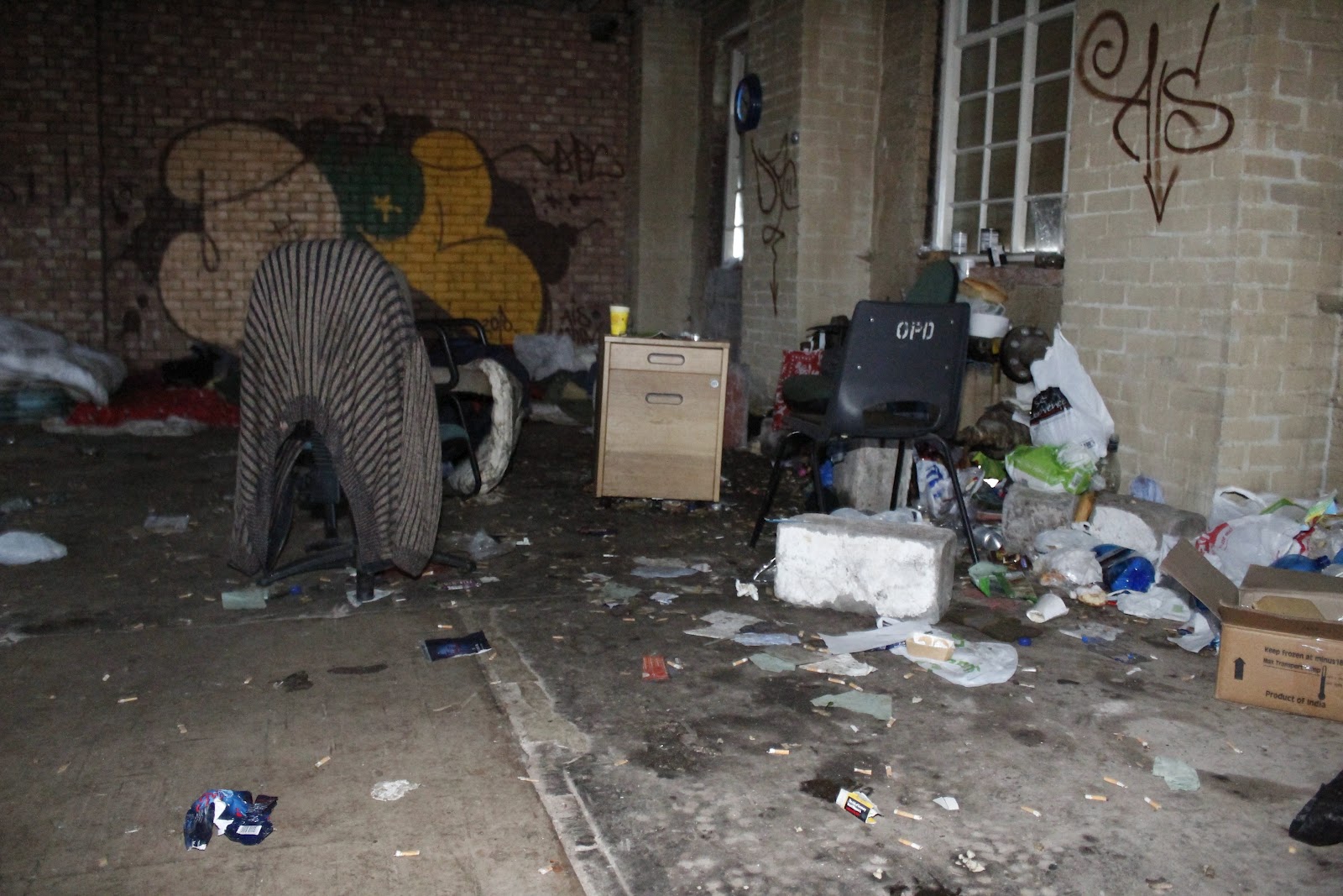
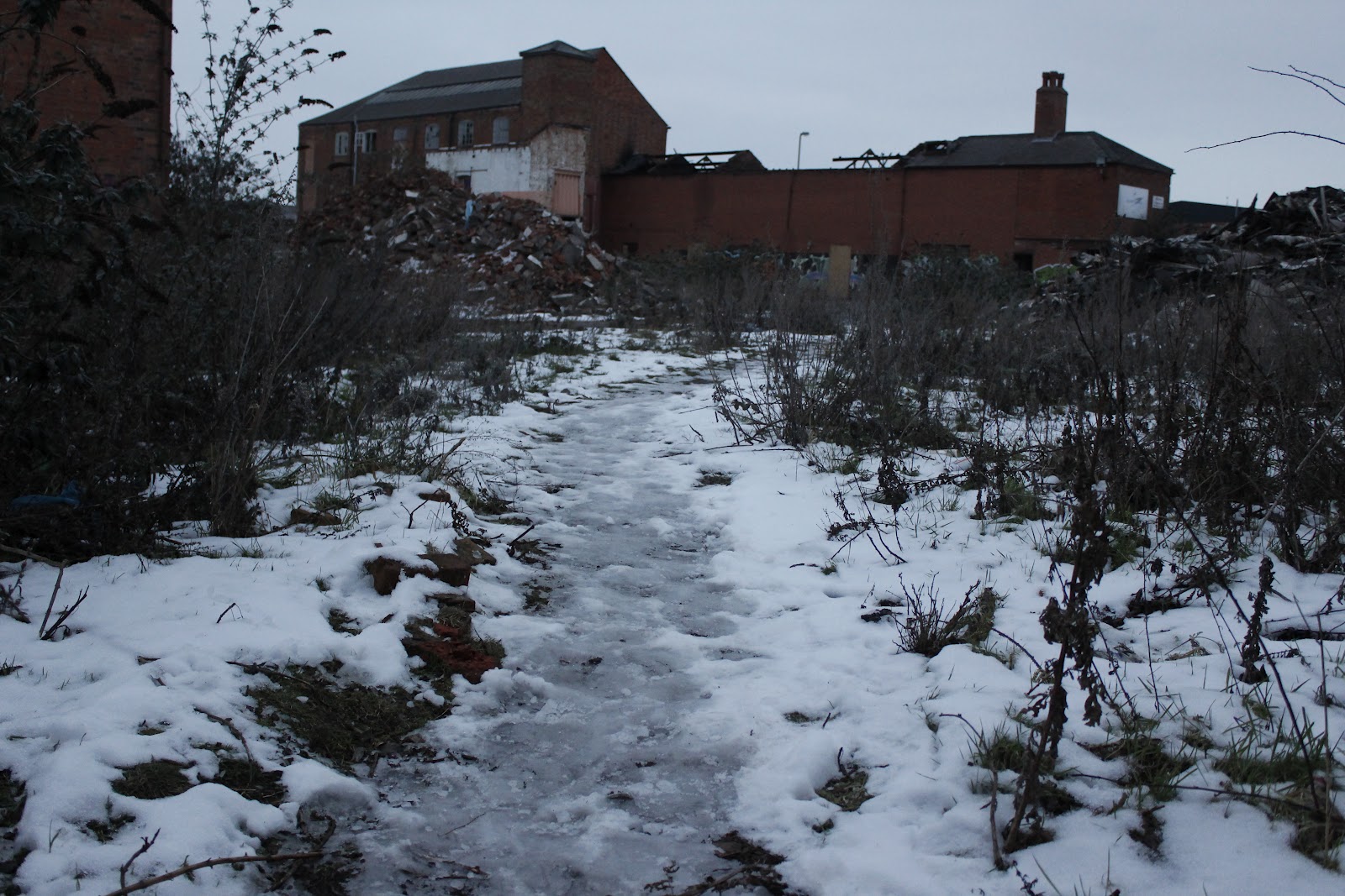
Although I freely admit that these pictures don't have the same artistic quality as the UrbanX pictures, some interesting questions are raised by them.  Firstly, on closer inspection of the old burnt out terraces, it would appear that people are still living in them (owner of the yellow Beetle, I think not).  To add further levity to this assumption, the footprints in the snow.  This route was no through route and only led to the old factory and the rear of these terraces, for all the rest of the area was fenced off.  Secondly, why do they have such interest in the Kiwi bird (New Zealanders maybe?).


Mercury prize

Through more Mercury reading, I have come across some fellow zealots who are wary of the planning on green field sites.

The CPRE (Campaign to Protect Rural England) are holding a road shows throughout Leicestershire for people to find out more about future planning systems and how to influence developments.

I shall be attending one of these events to get an idea about current plans that are ongoing throughout the county and what opposition there is to these.

12 February 2012

Leicester Urban Artists exhibition

There is no doubting that other artists have an opinion and viewpoint on the urban sprawl that is Leicester.

After taking a quick look at various galleries and exhibition spaces in Leicester, I cam across this little gem:


Tim Fowler (Leicester Train Station)


It will be interesting to see Tim Fowlers interpretation of the Urban area that it Leicester.

Leicester Slums

Whilst taking my son round the New Walk Museum today (for the recently opened dinosaur exhibition), I happened across the 'What's On' booklet at the museum, I stumbled across this useful up coming event:-

Ned Newitt: Leicester Slums
Sunday 22nd April
3.00pm
Newarke Houses Museum & Gardens
This popular and well-illustrated talk will provide a picture of a long vanished Leicester and should be of interest not just to historians and planners, but to anyone who lives in the inner city or has roots in Leicester. Ned Newitt's book on this subject was published last September by Breedon Books. Booking essential, £3.00 (refreshments included).


The information garnered from this talk could prove useful in establishing background into the city of Leicester.


09 February 2012

Spending a Penny


I also stumbled upon this interesting article on De Montfort University very own paper, The Demon.

Some local businessmen have bought an old run down art deco toilet block and are converting it into a cafe and deli.

This shows great iniative in using a building that would have otherwise have been left to rot (it had been unused for several years prior to the recent purchase).

Aylestone Meadows


Came across this article in the Leicester Mercury.  Aylestone Meadows are on the cusp of the city centre and provide a great outdoors space for walking, fishing and an escape from the city centre hussle.

A few years ago their were plans to build football pitches and club houses over this land.  However, after a block on the plans by the city council, these plans have been shelved.

Now, more than two years later, this survey has shown the area to be of a vastly diverse natural resource with over 600 different species of fauna and flora.

08 February 2012

Jamie Lewis flyer


I was handed this flyrer by one of the mechanics working in one of the garages underneath the viaduct of the old Great Central Railway.  I'm not sure of its relevance to this project but I thought that I might include here anyhow.

The big red arrow roughly points to the All Saints Road area as shown in the Gallery tab.

07 February 2012

Donisthorpe building


One thing I did wonder about this area of demolition was why certain building had been left standing whilst others (even though they appear to have been empty for quite some time) have been left standing.

Of particular interest is the old Donisthorpe and Co. Factory building.  It turns out that this building is Grade II listed, which would explain why it is still standing.

Interestingly, the reason that the gates are concreted together is because this area was regularly being used by travellers and gypsies, which the city council wasn't too happy with.  To prevent them settling here, the whole area has either been fenced off or concreate mounds have been put in to prevent access by motorhomes and caravans.

A look into the past

Whilst scouring the internet, I stumbled across a website that has gone into great detail about the area in and around the All Saints Road area.

http://www.gcrleicester.info/html/leicester_central.html.

As can be seen from Figure 1, the demolition work is in progress as of December 2007.
Figure 1
Today, this area, as can been seen from my pictures (under the Gallery tab) stands empty.  The chimney, seen in the background of this image, has been cleared too.


As can be seen from Figure 2, on the very far left of this images, as of 2001 the factory buildings, where the now vast empty area as it now stands, are still there.  The drain pipes and brickwork are still visible.

02 February 2012

Recon.

One of the areas that comes to mind as being an unused a vast tract of unused land in the city is that which can be found at All Saints Road area of Leicester.  Despite what Google Maps Satellite image (Figure 1)shows, this whole area consists of derelict or demolished buildings.


View All Saints Road Area in a larger map (Figure 1)

As can be seen from the map and outlined area, this area covers approx. 250m x 150m of inner city land that is currently siting unused.

This might not sound like a great deal of space, but when you see pictures of the size of area, it soon becomes apparent that this space could be used for lots of housing.

After speaking to some gentlemen who work in mechanics garages in the arches under the old railway viaduct, they suggested student accommodation and professional apartment are to be constructed on the site.

The gentlemen also informed me that the Westbridge Wharf apartment block (Figure 2) that had been built on part of the site in question sat with many of the apartments empty or given over to social housing.

Figure 2

Looking at Figure 1, you can see that the area of land in question covers approximately that similar to Tudor Road to the east, Vernon Street to the north Tyrell Street to the west and Bosworth Street to the south, just west of the Alexander Road area, over the River Soar.  The area consists of high density two bedroom terrace housing, perfect for supporting families or young professionals.  In an approximation of the size of the Alexander Road area, there are about 400 homes in this similar area.  From walking around this area, less than 1% of the homes are currently sat empty.

So, rather than building housing on the edge of the city and eating into green field areas, there is potential here to build useful housing that could accommodate many families and young professionals, without having to construct tower blocks of apartments that aren't used.